Nestled in the picturesque hills of Uttarakhand, Purola is a serene town that boasts breathtaking landscapes and a diverse topography. Understanding the terrain of Purola is crucial for various purposes, including urban planning, disaster management, environmental conservation, and tourism development. Geographic Information Systems (GIS) play a pivotal role in creating detailed and interactive terrain maps that provide invaluable insights into the region’s geographical features. In this blog post, we will delve into the significance and utility of a GIS-based terrain map of Purola, highlighting its features, benefits, and applications.
Understanding the Terrain of Purola
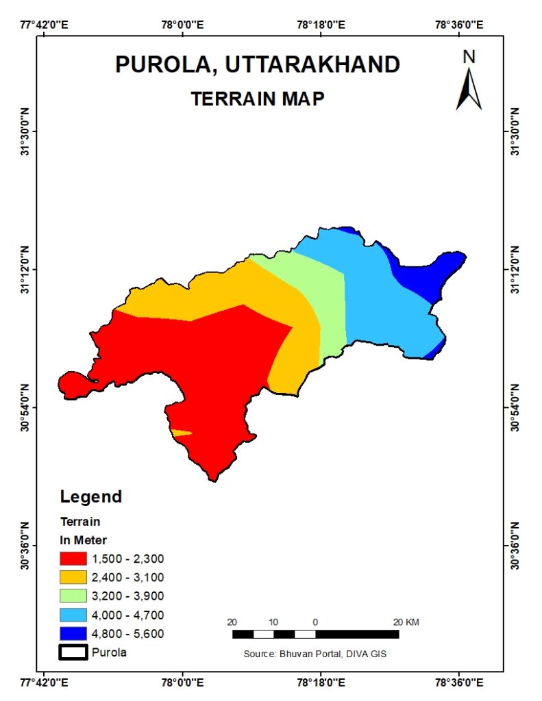
Purola is situated in the Uttarkashi district of Uttarakhand, surrounded by the majestic Himalayas. The terrain of Purola is characterized by steep hills, lush valleys, dense forests, and flowing rivers. This diverse topography not only contributes to the region’s natural beauty but also presents unique challenges and opportunities for development and conservation.
A GIS-based terrain map of Purola offers a detailed visual representation of these geographical features, enabling stakeholders to understand the intricate details of the landscape. By utilizing various data layers and analytical tools, GIS maps can depict elevation, slope, aspect, and other critical terrain attributes.
Features of a GIS-Based Terrain Map of Purola
- 3D Visualization: One of the standout features of a GIS-based terrain map is the ability to create 3D visualizations of the landscape. This feature provides a realistic view of Purola’s topography, making it easier to comprehend the elevation changes and the spatial distribution of geographical features.
- Detailed Elevation Data: GIS maps can incorporate Digital Elevation Models (DEMs) to provide precise elevation data. This information is crucial for identifying high and low points, understanding watershed boundaries, and planning infrastructure projects.
- Slope and Aspect Analysis: Slope and aspect are essential terrain attributes that influence soil erosion, vegetation growth, and construction feasibility. A GIS-based terrain map can generate slope and aspect maps, helping planners and environmentalists make informed decisions.
- Hydrological Features: The map can highlight rivers, streams, and other water bodies, along with their flow directions and catchment areas. This information is vital for water resource management, flood risk assessment, and conservation efforts.
- Layered Information: Users can overlay multiple data layers on the terrain map, such as land use, vegetation cover, soil types, and infrastructure. This layered approach provides a comprehensive view of the region’s natural and human-made features.
Benefits of Using a GIS-Based Terrain Map for Purola
- Enhanced Planning and Development: Government officials and urban planners can utilize a GIS-based terrain map to design sustainable development projects. The detailed topographical information helps in identifying suitable locations for infrastructure development, avoiding areas prone to landslides, and preserving natural resources.
- Improved Disaster Management: Purola, like many parts of Uttarakhand, is susceptible to natural disasters such as landslides, floods, and earthquakes. A GIS-based terrain map can aid in disaster risk assessment, emergency planning, and the implementation of mitigation measures.
- Environmental Conservation: The terrain map can assist environmentalists in identifying ecologically sensitive areas that need protection. By analyzing the terrain attributes, conservationists can develop strategies to preserve biodiversity and prevent soil erosion.
- Tourism Development: Purola’s scenic beauty makes it a potential hotspot for tourism. A GIS-based terrain map can help in planning and promoting eco-tourism initiatives. It can identify trekking routes, viewpoints, and other tourist attractions, ensuring that tourism development is both sustainable and beneficial to the local economy.
- Resource Management: Effective management of natural resources such as water, forests, and minerals is possible with the help of a detailed terrain map. GIS technology enables the integration and analysis of various data sets, providing insights into the optimal use and conservation of these resources.
Applications of GIS-Based Terrain Maps in Purola
- Infrastructure Development: By analyzing elevation and slope data, engineers and planners can design roads, bridges, and buildings that are safe and resilient. The map helps in identifying the best routes for transportation networks and the most stable locations for construction.
- Agriculture: Farmers can use the terrain map to understand the suitability of different crops based on soil type, slope, and aspect. This information helps in improving agricultural productivity and managing land resources efficiently.
- Forestry: Forest managers can use the map to monitor forest cover, plan afforestation projects, and prevent illegal logging. The terrain information aids in understanding the distribution of different forest types and their health.
- Water Resource Management: The hydrological features highlighted in the map are essential for managing water resources. Authorities can use this information to plan water storage, distribution, and conservation projects, ensuring sustainable water supply for the community.
- Community Planning: Local communities can benefit from the terrain map by understanding the geographical context of their region. This knowledge empowers them to participate in local governance and development projects effectively.
Conclusion
A GIS-based terrain map of Purola, Uttarakhand, is an invaluable tool that provides detailed insights into the region’s topography. By offering a comprehensive and interactive view of the landscape, GIS maps empower stakeholders to make informed decisions that enhance planning, development, and conservation efforts. Whether it is for government planning, environmental conservation, disaster management, or tourism development, the utility of a GIS-based terrain map is undeniable. As technology continues to advance, the applications and benefits of GIS in mapping Purola will only expand, offering innovative solutions for the region’s future challenges and opportunities.