GIS & Remote Sensing Courses in Delhi
Learn GIS, Google Earth Engine, Python in GIS & Remote Sensing from PhD Faculty. Offline + Online classes from Vikaspuri, Delhi. Industry-ready curriculum with live projects & guaranteed placement support.
Download Brochure
500+
Students Trained
95%
Placement Rate
10+
Years Experience
15+
Hiring Partner
courses
Institute of GIS and Remote Sensing (Swastik Edustart)
Master the GIS and Remote Sensing with Swastik Edustart
Master the art of GIS and Remote Sensing with Swastik Edustart’s professional diploma and certificate programs.

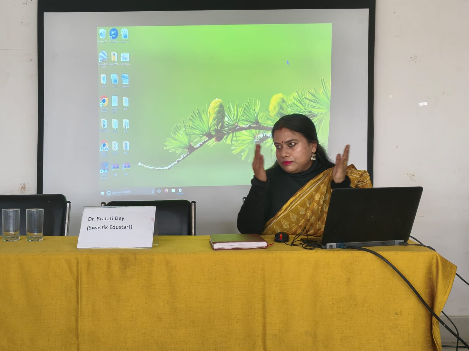
Dr. Bratati Dey – Head Faculty At Swastik Edustart
Dr. Bratati Dey is a distinguished academic and researcher with over a decade of expertise in Geography, Remote Sensing, and Geographic Information Systems (GIS). She leads the Geoinformatics department at Swastik Edustart, bringing a rare blend of rigorous academic excellence and applied research experience to her students
Post-Doctoral Research
Urban Expansion Simulation Modelling
Ph.D.
Geography – Remote Sensing & GIS
Gold Medalist
M.Sc. Geoinformatics
Technologies Covered
GIS Learning Resources
GIS Learning Resources & Industry Updates
Expert articles, tutorials, career guides and industry news from our faculty and GIS professionals.
Placements
Our Students Work at India’s Top GIS Companies
95% placement rate. Our dedicated placement cell connects graduates with India’s leading spatial data and mapping firms.


Industry Recognised Certification
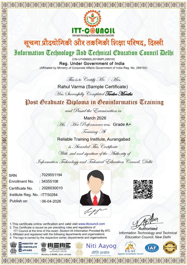
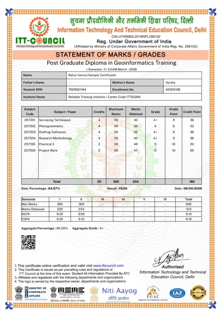
Get certified by an ITT Council recognized institute. Our credentials are valued by top private firms and government contractors across India and International also
Registered under Government of India.
ITT COUNCIL, Delhi is Provided Computer (IT) and Technical Courses Thorough Authorised Training Center (ATC).
Authorised Training Center In India and Out Of India
Ready to Start Your GIS Career?
Join 500+ students who transformed their careers with our expert-led GIS training programs. Limited seats for the next batch. · Certificate on completion
Download Brochure -2026-27
Why Swastik Edustart is Delhi’s Best GIS Training Institute
Swastik Edustart is a leading GIS Training Institute in Delhi, offering PG Diploma, Diploma, and Certificate courses in GIS & Remote Sensing with hands-on training and dedicated placement assistance.
We combine academic excellence with industry relevance — here’s what sets us apart from every other GIS training centre in Delhi.
# No. 1 GIS Institute
Industry-Oriented
Expert Trainers
Industry-Recognized Certification
Placement Assistance
Latest Tools & Technologies
Hands-on training with real datasets