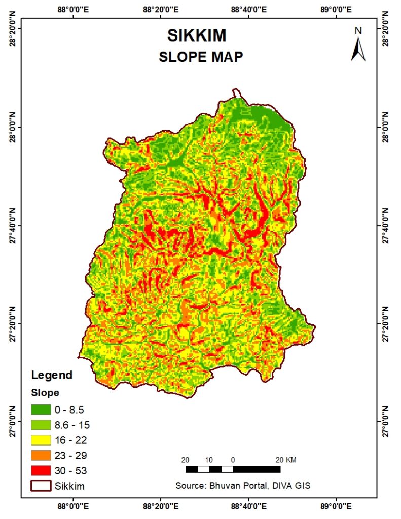
Sikkim, a picturesque state nestled in the Eastern Himalayas, is renowned for its stunning landscapes, diverse flora and fauna, and rich cultural heritage. One of the essential tools for understanding the geographical and topographical intricacies of this region is the slope map. In this blog post, we will delve into the significance of the slope map of Sikkim, its applications, and how it aids in various fields such as agriculture, urban planning, and environmental conservation.
What is a Slope Map?
A slope map is a specialized type of topographical map that illustrates the steepness or incline of the terrain. It uses color gradients or contour lines to represent different slope angles, making it easier to visualize the landscape’s variations in elevation. In the context of Sikkim, a slope map is particularly crucial due to the state’s predominantly mountainous terrain.
Importance of the Slope Map of Sikkim
- Agriculture and Land Use Planning:
- The slope map of Sikkim plays a vital role in agriculture by helping farmers and planners identify suitable areas for cultivation. Steeper slopes are prone to soil erosion and may not be ideal for certain types of crops. By using the slope map, sustainable agricultural practices can be implemented, ensuring better crop yields and soil conservation.
- Urban and Infrastructure Development:
- Sikkim’s rapid urbanization and infrastructure development require careful planning to avoid adverse environmental impacts. The slope map aids architects, engineers, and urban planners in selecting appropriate sites for construction, designing stable structures, and minimizing the risk of landslides.
- Disaster Management:
- Sikkim is vulnerable to natural disasters such as landslides and earthquakes. The slope map is an invaluable tool in disaster management and mitigation efforts. By identifying high-risk areas, authorities can implement preventive measures, conduct risk assessments, and plan evacuation routes effectively.
- Environmental Conservation:
- Preserving Sikkim’s rich biodiversity and natural habitats is crucial for maintaining ecological balance. The slope map assists in identifying areas that need protection due to their steep gradients and fragile ecosystems. This information is vital for formulating conservation strategies and managing protected areas.
How to Interpret the Slope Map of Sikkim
Interpreting a slope map involves understanding the color gradients or contour lines that represent different slope angles. Typically, flatter areas are depicted in lighter colors, while steeper slopes are shown in darker shades. Here are some key points to consider when analyzing the slope map of Sikkim:
- Flat to Gentle Slopes (0-10 degrees): Suitable for most agricultural activities and urban development.
- Moderate Slopes (10-20 degrees): May require terracing for agriculture; careful planning needed for construction.
- Steep Slopes (20-30 degrees): High risk of soil erosion and landslides; limited agricultural use.
- Very Steep Slopes (30+ degrees): Generally unsuitable for agriculture or construction; focus on conservation and preventing soil erosion.
Applications of the Slope Map in Various Fields
The slope map of Sikkim is utilized in numerous fields to enhance understanding and decision-making:
- Geological Surveys: Geologists use slope maps to study land formations and predict geological events.
- Tourism: Identifying safe and scenic trekking routes to promote eco-tourism while ensuring the safety of tourists.
- Forestry: Managing forest resources and planning reforestation projects to prevent soil erosion on steep slopes.
- Water Resource Management: Designing efficient irrigation systems and managing watershed areas.
Conclusion
The slope map of Sikkim is an indispensable tool for a wide range of applications, from agriculture and urban planning to disaster management and environmental conservation. By providing detailed insights into the terrain’s gradient, the slope map enables informed decision-making, promotes sustainable development, and helps protect Sikkim’s natural beauty. Understanding and utilizing the slope map effectively can lead to a balanced approach to development and conservation in this enchanting Himalayan state.
For those interested in exploring the slope map of Sikkim further, several online resources and government portals offer detailed maps and data. Engaging with these tools can provide a deeper appreciation of Sikkim’s unique geographical features and the importance of thoughtful land use planning.


