Welcome to our comprehensive GIS exploration of the Digital Elevation Model (DEM) of Dharamshala, Himachal Pradesh. In this blog post, we’ll take an in-depth look at the DEM data of Dharamshala and explore how Geographic Information Systems (GIS) technology enables us to gain valuable insights into the region’s terrain, elevation, and geographical features. Join us on this journey as we uncover the hidden nuances of Dharamshala’s landscape through the lens of GIS.
Exploring Dharamshala’s Topography: Dharamshala, nestled in the lap of the Himalayas, is renowned for its breathtaking scenery and diverse topography. From lush green valleys to snow-capped peaks, the region offers a stunning visual feast for nature lovers and adventurers alike. Through GIS technology, we can delve deeper into Dharamshala’s topography and gain a better understanding of its geographical features.
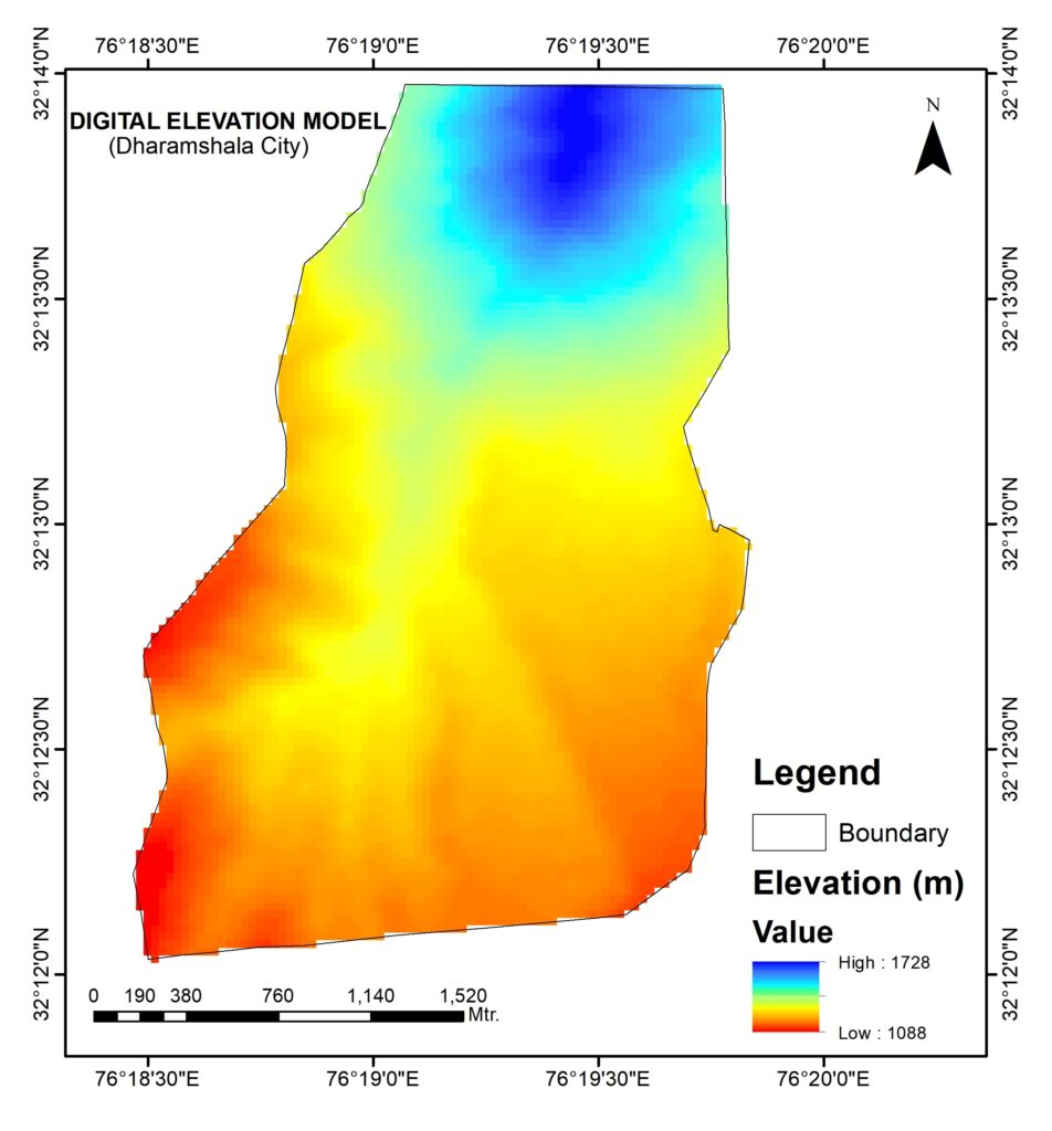
Understanding DEM Data: The Digital Elevation Model (DEM) represents the elevation of the Earth’s surface, capturing variations in terrain height with precision. In the context of Dharamshala, DEM data provides us with a detailed three-dimensional representation of the region’s topography. By utilizing GIS tools, we can visualize and analyze this data to unravel the geographical complexities of Dharamshala’s landscape.
Mapping Terrain Features: With DEM data at our disposal, we can create high-resolution maps that accurately depict Dharamshala’s terrain features. From identifying mountain ranges and valleys to mapping river courses and ridgelines, GIS technology allows us to create detailed terrain maps that are invaluable for various applications, including urban planning, environmental management, and disaster risk assessment.
Analyzing Slope and Aspect: One of the key applications of DEM data is the analysis of slope and aspect. By calculating slope angles and aspect orientations, GIS specialists can assess terrain characteristics such as steepness and orientation to sunlight. This information is essential for a wide range of purposes, including land use planning, agriculture, and infrastructure development.
Visualizing Land Cover: In addition to terrain analysis, DEM data facilitates the visualization of land cover in Dharamshala. By overlaying elevation data with other spatial datasets, such as satellite imagery and vegetation maps, GIS professionals can create comprehensive land cover maps that highlight different land use categories and ecological zones. This information is crucial for biodiversity conservation, habitat management, and land resource planning.
Conclusion: As we conclude our exploration of the Digital Elevation Model (DEM) of Dharamshala, it’s clear that Geographic Information Systems (GIS) technology plays a pivotal role in understanding and analyzing the geographical landscape of this Himalayan town. From mapping terrain features to analyzing slope and aspect, DEM data offers a wealth of information that enriches our understanding of Dharamshala’s natural environment. Whether you’re a GIS enthusiast, environmental researcher, or simply curious about Dharamshala’s topography, exploring the DEM of this enchanting region is an enlightening journey that deepens our appreciation of the Earth’s diverse landscapes.