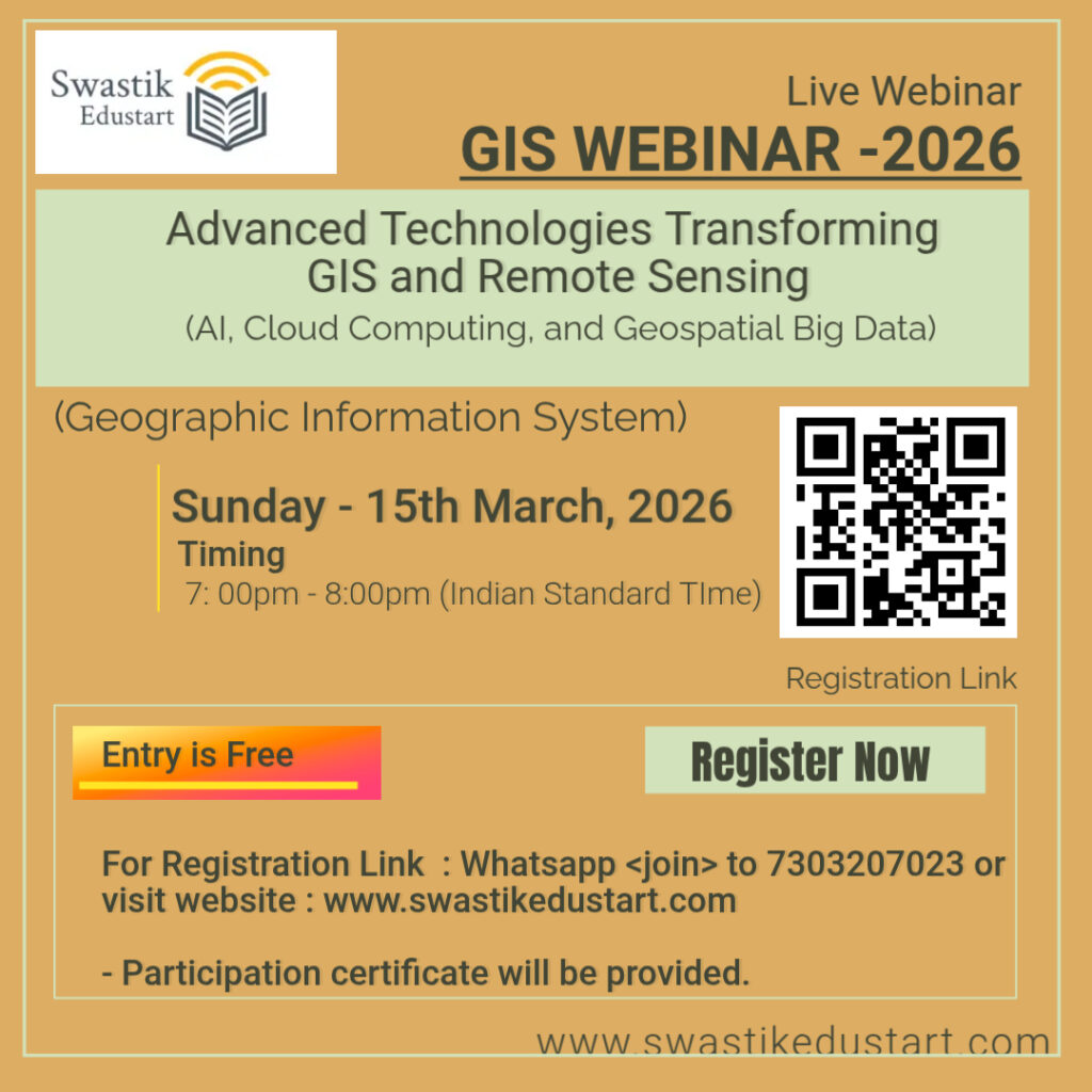
News & Updates

Your blog category

News & Updates

Admissions-2026

ADMISSION – 2026 (Diploma and Certificate Courses) Steps-Registration-Application Fees Payment Rs.200/- and Admission Month-Online Application Form Submission

sbsc
News & Updates

AI in Geography: Swastik Edustart & SBSC Workshop Highlights

AI in Geography: Swastik Edustart & SBSC Workshop Highlights The landscape of modern geography is shifting from static maps to dynamic data models. Recently, Swastik EduStart, in collaboration with the Department of Geography, Shaheed Bhagat Singh College (SBSC), hosted an intensive workshop: “Application of AI in Geospatial Studies.” This session was designed to equip students

News & Updates

Amenity Map of Delhi: A Complete Guide to Understanding the City’s Educational & Urban Infrastructure

Delhi, the vibrant capital of India, is a city defined by its diversity, rich history, expanding neighborhoods, and rapidly evolving infrastructure. One of the most effective ways to understand a city’s spatial distribution of services is through an Amenity Map. The Amenity Map of Delhi provides a visual representation of essential facilities—particularly schools, colleges, roads,

News & Updates

When the Mountains Turn Fierce: Understanding Flood Inundated Areas in Chamba, Uttarakhand

Uttarakhand’s breathtaking Himalayan landscapes often hide an unsettling truth—its terrain is one of the most disaster-prone in India. Chamba, a beautiful town located in the Tehri Garhwal region, has increasingly found itself in the spotlight due to rising flood risks and frequent extreme weather events. As climate patterns shift and rainfall intensifies, understanding flood inundated

News & Updates

Land Use and Land Cover Change Detection in Varanasi, Uttar Pradesh (2015–2025)

Introduction Land Use and Land Cover (LULC) change detection is a crucial tool for understanding how cities evolve over time. In Varanasi, one of India’s oldest and most dynamic cities, rapid urbanization has significantly transformed its landscape. Using remote sensing data from USGS Explorer, this study visualizes the shift in land use patterns between 2015

Scroll to Top