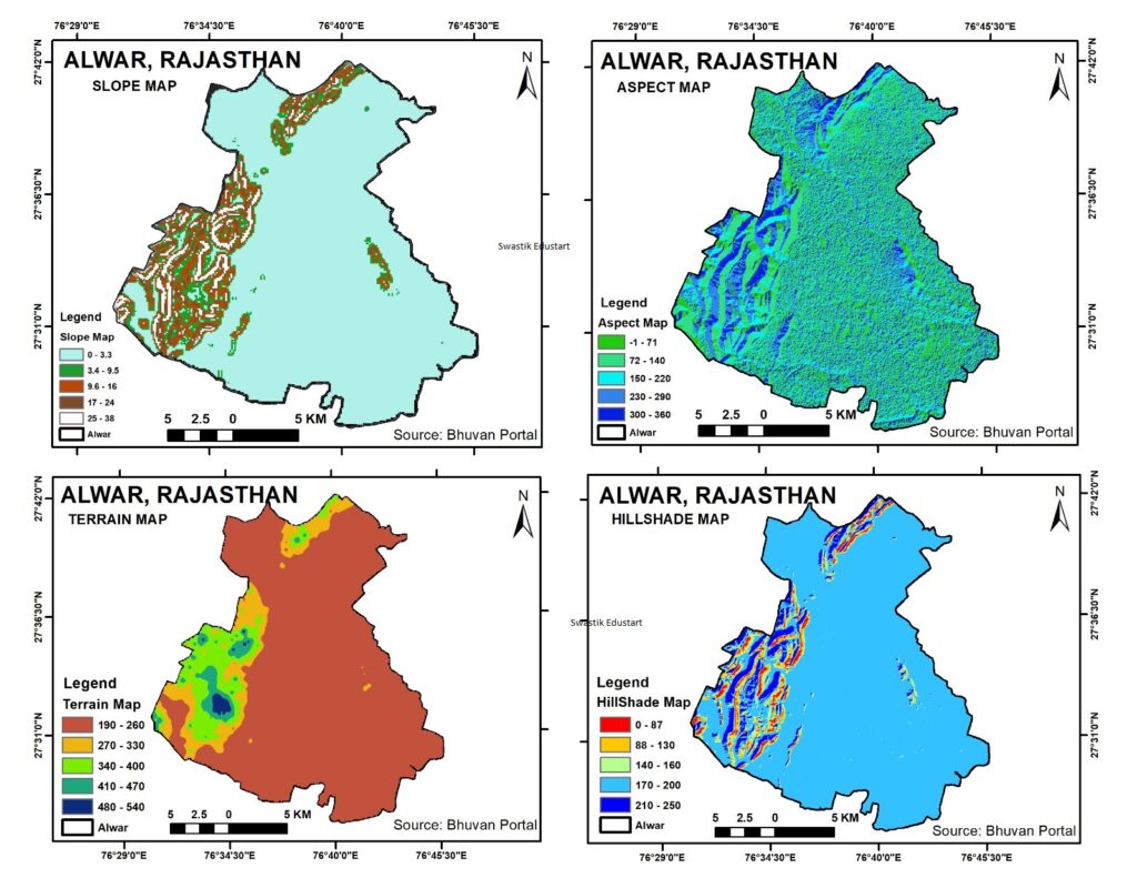
Hillshade Map from DEM, Geographic Information Systems (GIS) have revolutionized the way we visualize and analyze geographical and topographical data. One powerful tool in GIS is the hillshade map, which provides a stunningly detailed view of the terrain by simulating the effect of sunlight on the landscape. In this blog post, we’ll explore how Digital Elevation Model (DEM) data can be used to create a hillshade map of Alwar, Rajasthan, revealing the intricate details of its terrain.
What is a Hillshade Map?
A hillshade map is a grayscale 3D representation of terrain created from elevation data. By simulating light source conditions—typically assuming the sun is shining from the northwest—it shows how shadows and highlights fall on the landscape. This technique accentuates the relief, providing a clear visualization of the topography.
Why Alwar, Rajasthan?
Alwar, located in the northeastern part of Rajasthan, India, is a region rich in history and natural beauty. It is surrounded by the Aravalli Range, one of the oldest mountain ranges in the world. The diverse topography of Alwar, with its valleys, hills, and plains, makes it an excellent subject for hillshade mapping.
Creating a Hillshade Map of Alwar
- Obtaining DEM Data:
- Source: DEM data for Alwar can be obtained from various sources such as the USGS Earth Explorer or the Copernicus Open Access Hub.
- Resolution: For detailed analysis, a DEM with a resolution of 30 meters or better is preferred.
- Processing the Data:
- Software: Use GIS software like QGIS . These tools have built-in functionalities to create hillshade maps.
- Steps:
- Import the DEM data into the GIS software.
- Navigate to the hillshade tool. In QGIS, this can be found under Raster > Analysis > Hillshade.
- Configure the azimuth and altitude of the light source. Common settings are an azimuth of 315 degrees (northwest) and an altitude of 45 degrees.
- Generate the hillshade map, adjusting the z-factor if necessary to account for the scale of the DEM data.
- Visualizing the Hillshade Map:
- The hillshade map will display the terrain of Alwar in a grayscale image where the nuances of the landscape are highlighted. Hills, valleys, and plains will be visually distinct, giving a pseudo-3D effect.
Benefits of Hillshade Maps
- Enhanced Topographic Understanding: Hillshade maps provide an intuitive understanding of the terrain, which is beneficial for geologists, urban planners, and environmentalists.
- Historical and Cultural Insights: For regions like Alwar, with its rich history and numerous forts and palaces, hillshade maps can help in understanding how the terrain influenced historical developments.
- Tourism and Education: Such maps can be used to create engaging visual content for tourists and educational purposes, showcasing the natural beauty of the region.
Conclusion
The creation of hillshade maps using DEM data is a powerful technique in GIS, offering detailed and visually appealing representations of terrain. For Alwar, Rajasthan, this method reveals the stunning complexity of the region’s topography, highlighting the natural beauty and historical significance embedded in its landscape. Whether for academic research, urban planning, or simply appreciating the natural world, hillshade maps provide an invaluable perspective on the geography of Alwar.
By leveraging the power of DEM data and modern GIS tools, we can explore and understand the intricate details of terrains like never before, bringing the ancient and diverse landscape of regions like Alwar to life in new and exciting ways.
Keywords
- Hillshade Map
- Digital Elevation Model (DEM)
- GIS
- Alwar, Rajasthan
- Terrain Visualization
- Topography
- Aravalli Range
- USGS Earth Explorer
- Copernicus Open Access Hub
- QGIS
- ArcGIS
- Geographic Information Systems
- 3D Terrain Mapping
- Remote Sensing
- Environmental Analysis
- Urban Planning
- Historical Geography
- Tourism Mapping
- Educational Tools