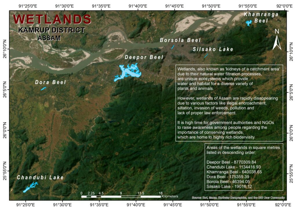
Kamrup district in Assam is home to a diverse array of wetlands that play a crucial role in maintaining ecological balance, supporting biodiversity, and sustaining the livelihoods of local communities. Wetland mapping is an essential process for understanding these valuable ecosystems and ensuring their conservation and sustainable use. In this blog post, we will explore the significance of wetland mapping in Kamrup district, the techniques used, and the benefits of such initiatives.
Importance of Wetlands in Kamrup District
Wetlands in Kamrup district, including marshes, swamps, and floodplains, provide numerous ecological, economic, and social benefits. They act as natural water filters, trapping pollutants and sediments, and play a vital role in flood control by absorbing excess rainfall. Wetlands are also critical habitats for a wide range of flora and fauna, including migratory birds, fish, and amphibians. Furthermore, they support agriculture and fisheries, which are essential for the local economy.
The Need for Wetland Mapping
Wetland mapping is the process of identifying, delineating, and categorizing wetlands using various technologies and methodologies. It is crucial for several reasons:
- Conservation and Management: Accurate mapping helps in identifying areas that need protection and restoration, ensuring that conservation efforts are focused where they are most needed.
- Policy Making: Detailed maps provide essential data for policymakers to create effective regulations and management plans to protect wetlands.
- Sustainable Development: Understanding the distribution and condition of wetlands aids in planning sustainable land-use practices that balance development with ecological preservation.
- Disaster Mitigation: Wetlands play a key role in flood control and climate regulation. Mapping helps in integrating wetland conservation into broader disaster management strategies.
Techniques Used in Wetland Mapping
Several advanced techniques are employed in wetland mapping to ensure accuracy and reliability:
- Remote Sensing: Satellite imagery and aerial photography are widely used to identify and delineate wetlands. These technologies provide large-scale coverage and can detect changes over time.
- Geographic Information Systems (GIS): GIS technology is used to analyze spatial data, integrate various data sources, and create detailed wetland maps. It allows for the layering of different types of information, such as topography, hydrology, and vegetation.
- Ground Truthing: Field surveys are conducted to validate remote sensing data. This involves physically visiting wetland sites to collect accurate information on vegetation types, water levels, and soil conditions.
- Hydrological Modeling: This technique uses data on water flow and levels to predict the presence and extent of wetlands, especially in floodplain areas.
Case Study: Wetland Mapping in Deepor Beel
Deepor Beel, a Ramsar site located in Kamrup district, is an excellent example of how wetland mapping can benefit conservation efforts. This freshwater lake supports a rich biodiversity, including several endangered species. Through wetland mapping initiatives, conservationists have been able to:
- Identify Key Habitats: Mapping has highlighted critical areas that serve as breeding and feeding grounds for various species.
- Monitor Changes: Regular mapping helps in tracking changes in water levels, vegetation cover, and land use, which is vital for adaptive management.
- Engage Stakeholders: Detailed maps provide a visual tool to engage local communities, policymakers, and researchers, promoting collaborative conservation efforts.
Benefits of Wetland Mapping
The benefits of wetland mapping in Kamrup district are manifold:
- Enhanced Conservation Efforts: Accurate data helps in prioritizing conservation actions and allocating resources efficiently.
- Improved Land Use Planning: Authorities can use maps to guide sustainable development, avoiding activities that could harm wetland ecosystems.
- Biodiversity Protection: Mapping helps in identifying critical habitats, ensuring the protection of endangered species and overall biodiversity.
- Community Involvement: Providing communities with detailed information about their local wetlands fosters a sense of ownership and encourages sustainable practices.
- Disaster Risk Reduction: Wetland mapping is integral to flood management strategies, helping mitigate the impact of natural disasters.
Challenges in Wetland Mapping
Despite its importance, wetland mapping faces several challenges:
- Data Limitations: Obtaining high-resolution, up-to-date satellite images can be expensive and technically challenging.
- Seasonal Variability: Wetlands can change dramatically with seasons, complicating the mapping process.
- Human Activities: Rapid urbanization and agricultural expansion can alter wetland boundaries, requiring continuous monitoring and updating of maps.
- Technical Expertise: Effective mapping requires specialized skills in remote sensing, GIS, and field survey techniques, which may not always be available.
Conclusion
Wetland mapping in Kamrup district is an essential tool for conserving these critical ecosystems and ensuring sustainable development. By employing advanced technologies and involving local communities, we can protect the valuable wetlands of Kamrup for future generations. Accurate mapping not only aids in conservation but also supports policy-making, sustainable land use, and disaster risk reduction, making it a cornerstone of environmental management in the region.
Embracing wetland mapping initiatives will ensure that the rich biodiversity and ecological functions of Kamrup’s wetlands are preserved, contributing to the well-being of the local communities and the overall health of the environment.


