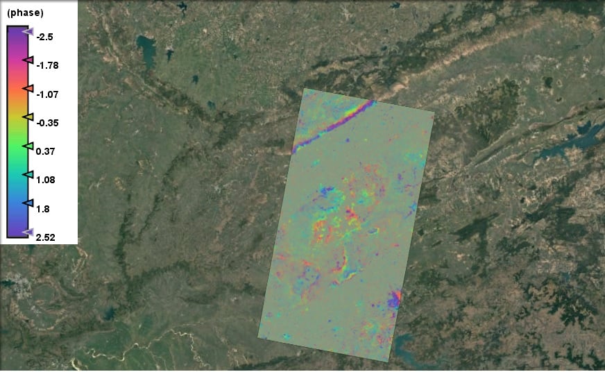
Land subsidence is a critical issue affecting many regions worldwide, often resulting from natural processes or human activities such as groundwater extraction, mining, or construction. Monitoring and understanding these changes are vital for urban planning, infrastructure maintenance, and environmental conservation. Our student Kartikey has taken a significant step in this direction by creating an interferogram using Sentinel-1 Synthetic Aperture Radar (SAR) imagery to monitor land subsidence in Jabalpur, Madhya Pradesh.
What is InSAR?
Interferometric Synthetic Aperture Radar (InSAR) is a powerful remote sensing technique that uses radar signals from Earth-orbiting satellites to measure changes in land surface altitude with remarkable precision. By comparing radar images taken at different times, InSAR can detect and map even minute surface deformations over large areas. This method provides high-density measurements and exceptional spatial detail, making it an invaluable tool for studying land subsidence, earthquakes, and other geophysical phenomena.
Kartikey’s Project: Monitoring Jabalpur
Data Acquisition and Processing
Kartikey utilized data from the Sentinel-1 satellites, part of the European Space Agency’s Copernicus program. Sentinel-1 provides continuous all-weather, day-and-night radar imagery, which is ideal for monitoring surface changes over time. The specific focus of Kartikey’s project was Jabalpur, a city in Madhya Pradesh known for its geological activity and susceptibility to land subsidence.
Creating the Interferogram
An interferogram is essentially a visual representation of phase differences between two SAR images taken at different times. These phase differences can indicate changes in land surface altitude. Kartikey processed pairs of Sentinel-1 images using specialized software to generate the interferogram. This involved:
- Image Preprocessing: Correcting for geometric distortions and aligning the images precisely.
- Interferogram Generation: Calculating the phase difference between the two images.
- Phase Unwrapping: Converting the phase difference information into meaningful displacement data.
- Geocoding: Translating the displacement data into a map that accurately represents the geographic area of interest.
Analyzing the Results
The interferogram created by Kartikey revealed significant insights into the land subsidence patterns in Jabalpur. By analyzing the displacement data, it was possible to identify areas experiencing varying degrees of subsidence. The high resolution and spatial detail of the interferogram allowed for precise pinpointing of subsidence hotspots, which can be crucial for urban planners and policymakers in mitigating potential risks.
Implications and Future Directions
Kartikey’s work exemplifies the practical application of advanced remote sensing techniques in addressing real-world problems. The detailed subsidence map of Jabalpur can serve multiple purposes:
- Urban Planning: Helping authorities to make informed decisions about land use and construction.
- Infrastructure Maintenance: Identifying areas where subsidence could pose a risk to buildings, roads, and other infrastructure.
- Environmental Conservation: Monitoring and mitigating the impacts of subsidence on natural landscapes.
Future directions for this research could include extending the monitoring to other regions prone to subsidence, incorporating more frequent SAR acquisitions for real-time monitoring, and integrating InSAR data with other geospatial datasets for a comprehensive analysis of land surface dynamics.
Conclusion
Kartikey’s innovative use of Sentinel-1 SAR imagery to create an interferogram for monitoring land subsidence in Jabalpur highlights the significant potential of InSAR technology. By providing high-resolution, detailed measurements of surface changes, InSAR enables better understanding and management of geological processes. This project not only contributes valuable data to the scientific community but also offers practical benefits for urban development and environmental management in Jabalpur and beyond.
Through projects like this, our students continue to push the boundaries of what is possible with remote sensing technology, demonstrating its critical role in addressing contemporary geospatial challenges.
This project not only showcases Kartikey’s technical expertise and innovative approach but also underscores the importance of remote sensing in tackling geospatial challenges. By leveraging InSAR technology, the study provides a detailed subsidence map that can aid in proactive decision-making, ensuring safer urban environments and sustainable land management practices in Jabalpur.