Skip to content
Swastik Edustart
HOME
FACULTY PROFILE
COURSES
PG Diploma-Geoinformatics
Diploma in GIS & Remote Sensing
GIS Certificate Course
Short Courses
Python & Google Earth Engine Course for Geospatial Analysis
View All Courses
PLACEMENTS
CONTACT
GALLERY
GIS JOBS
ADMISSIONS-2026
BLOG
Swastik Edustart
HOME
FACULTY PROFILE
COURSES
PG Diploma-Geoinformatics
Diploma in GIS & Remote Sensing
GIS Certificate Course
Short Courses
Python & Google Earth Engine Course for Geospatial Analysis
View All Courses
PLACEMENTS
CONTACT
GALLERY
GIS JOBS
ADMISSIONS-2026
BLOG
✆
+91 730-320-7023
Enquiry Now
Enquiry Now
Geospatial analysis
News & Updates
#1 Google Earth Engine: A Comprehensive Guide for Data Analysis and Visualization
News & Updates
Mapping Object-Based Classification: A Comprehensive Guide
News & Updates
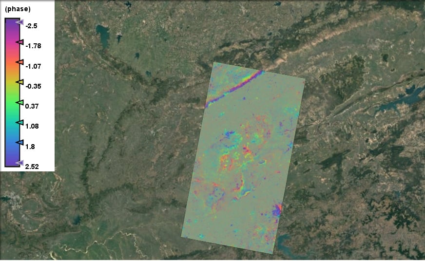
Monitoring Land Subsidence in Jabalpur: Interferogram Using Sentinel-1 SAR Imagery