- Understanding the Uttarakhand Earthquake 2022-23
- The Importance of Earthquake Mapping
- Techniques Used in Earthquake Mapping
- Impact of the Uttarakhand Earthquake
- Preparedness and Mitigation Strategies
- The Role of Technology in Earthquake Response
- Case Studies: Lessons from the Past
- Community Involvement and Resilience
- Conclusion
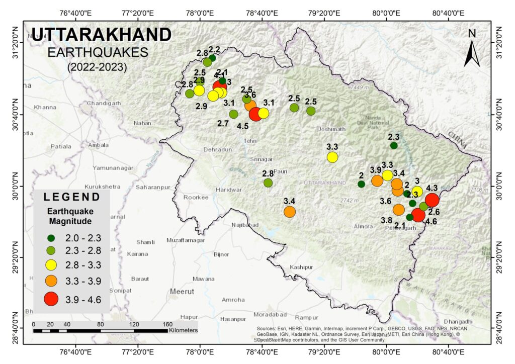
he state of Uttarakhand in India is known for its picturesque landscapes and serene environment. However, it is also situated in a seismically active region, making it prone to earthquakes. The Uttarakhand Earthquake of 2022-23 has once again highlighted the vulnerability of this region. In this blog post, we will delve into the details of the earthquake, its impact, and the importance of mapping and disaster preparedness.
Understanding the Uttarakhand Earthquake 2022-23
The Uttarakhand Earthquake of 2022-23 was a significant seismic event that struck the northern Indian state, causing widespread damage and raising concerns about earthquake preparedness in the region. The earthquake had a magnitude of 6.3 on the Richter scale and was felt across several neighboring states, including Himachal Pradesh and Uttar Pradesh. The quake’s epicenter was located near the town of Chamoli, an area already known for its seismic activity.
The Importance of Earthquake Mapping
Earthquake mapping plays a crucial role in understanding the impact of seismic events. Accurate mapping helps in identifying the affected areas, assessing the extent of damage, and planning for future mitigation strategies. Here’s how earthquake mapping is beneficial:
- Damage Assessment: By mapping the earthquake’s epicenter and the affected regions, authorities can quickly assess the damage and prioritize relief efforts.
- Risk Analysis: Mapping helps in identifying high-risk zones, enabling better urban planning and construction practices to minimize future risks.
- Resource Allocation: With precise maps, resources can be allocated more efficiently, ensuring timely aid to the most affected areas.
- Public Awareness: Maps can be used to educate the public about earthquake-prone areas, promoting better preparedness and response strategies.
Techniques Used in Earthquake Mapping
Several advanced techniques are employed in earthquake mapping to ensure accuracy and reliability:
- Remote Sensing: Satellite imagery and aerial photography provide real-time data on the affected regions, helping in the swift assessment of damage.
- Geographic Information Systems (GIS): GIS technology is used to create detailed maps that combine various data sources, including ground surveys, remote sensing data, and historical records.
- Seismographic Networks: A network of seismographs records the earthquake’s intensity and helps in pinpointing the epicenter and understanding the seismic waves’ propagation.
Impact of the Uttarakhand Earthquake
The Uttarakhand Earthquake of 2022-23 had a profound impact on the region:
- Infrastructure Damage: Several buildings, roads, and bridges were damaged, disrupting daily life and economic activities. The towns of Chamoli and Joshimath witnessed significant structural damage, with many buildings developing cracks and some collapsing entirely.
- Human Casualties: The earthquake resulted in numerous injuries and fatalities, highlighting the need for better preparedness and response mechanisms. The immediate aftermath saw a rush to rescue trapped individuals and provide medical aid to the injured.
- Environmental Impact: Landslides triggered by the earthquake caused further damage to the environment and infrastructure. The fragile Himalayan terrain, already susceptible to erosion and landslides, saw increased instability, leading to blocked roads and isolated communities.
- Economic Impact: The earthquake had a substantial economic impact, with damage to property and infrastructure running into millions of dollars. The tourism industry, a major economic driver in the region, also suffered as visitors canceled their plans fearing aftershocks and further instability.
Preparedness and Mitigation Strategies
To mitigate the impact of future earthquakes, it is essential to implement effective preparedness strategies:
- Building Codes: Enforcing stringent building codes that require earthquake-resistant designs can significantly reduce structural damage. Buildings should be constructed with materials and techniques that can withstand seismic forces.
- Early Warning Systems: Developing and deploying early warning systems can provide crucial time to take protective measures before the shaking starts. Technologies that detect the first waves of an earthquake and send alerts can save countless lives.
- Public Education: Educating the public about earthquake preparedness, including emergency kits and safe evacuation procedures, can save lives. Awareness campaigns, drills, and community programs should be a regular part of disaster management.
- Regular Drills: Conducting regular earthquake drills in schools, offices, and communities ensures that people know how to respond during an actual event. These drills help inculcate a culture of preparedness and quick, effective action.
The Role of Technology in Earthquake Response
Technology has a vital role in both the immediate response to earthquakes and in long-term preparedness. Mobile apps can alert users to an earthquake’s occurrence and provide instructions on safety measures. Drones and remote sensors can assess damage in inaccessible areas, providing vital information for rescue operations. Additionally, data analytics can help predict the areas most at risk and guide infrastructure development to mitigate damage.
Case Studies: Lessons from the Past
Looking at past earthquakes in the region provides valuable lessons. The 1999 Chamoli earthquake, which had a magnitude of 6.8, caused significant damage and highlighted the region’s vulnerability. Comparing the responses and outcomes of past and recent events can guide improvements in current strategies.
Community Involvement and Resilience
Building resilience is not just about infrastructure and technology; it’s also about community involvement. Local communities should be involved in planning and decision-making processes. Their local knowledge and experience are invaluable in creating effective, culturally appropriate preparedness plans. Community-led initiatives can also foster a sense of ownership and responsibility towards disaster preparedness.
Conclusion
The Uttarakhand Earthquake of 2022-23 serves as a stark reminder of the region’s seismic vulnerability. Accurate mapping and effective disaster preparedness are crucial in mitigating the impact of such natural disasters. By leveraging advanced mapping techniques, promoting public awareness, and involving the community, we can enhance our resilience and ensure a safer future for the people of Uttarakhand.
Understanding the importance of earthquake mapping and preparedness can significantly reduce the damage and save lives. Let’s work together to build a resilient Uttarakhand, ready to face future challenges with strength and preparedness. Through coordinated efforts and the integration of modern technology, we can transform our response to earthquakes and safeguard the well-being of our communities.


