Whether you’re exploring a new city or finding your way around a massive shopping mall, maps are your guiding light. But have you ever come across a location map and wondered how it differs from a regular map? Let’s dive in and uncover what location maps are all about!
What is a Location Map?
A location map is a specialized map designed to show the geographical location of a specific place, area, or point of interest. It’s like a snapshot that highlights where something is in relation to its surroundings. These maps come in various forms, from simple sketches to detailed, digitized versions.
Key Features of Location Maps
- Pinpoint Accuracy: Location maps are focused on providing precise details about a particular place, be it a landmark, a business, or an event venue. They often include not only streets and landmarks but also vital information about the location’s latitude and longitude.
- Easy Navigation: They help people navigate from one place to another by displaying directions, nearby landmarks, and sometimes even distances. This assists in getting to a location efficiently.
- Simplicity and Clarity: Location maps are designed to be straightforward and easy to understand. They don’t overwhelm you with too much information but rather provide the necessary details for orientation and direction.
- Customization: Depending on the purpose, these maps can be tailored to include additional information like public transport stops, parking areas, or other amenities relevant to the location.
Uses of Location Maps
- Businesses: Many businesses use location maps on their websites or mobile apps to make it easier for customers to find their physical locations. This is particularly useful for stores, restaurants, and service-based companies.
- Tourism and Travel: When you’re planning a trip or exploring a new area, location maps can be your best friend. They help in locating attractions, accommodations, and other points of interest.
- Events and Venues: From music concerts to sports events, having a clear location map ensures attendees can find the venue without a hitch.
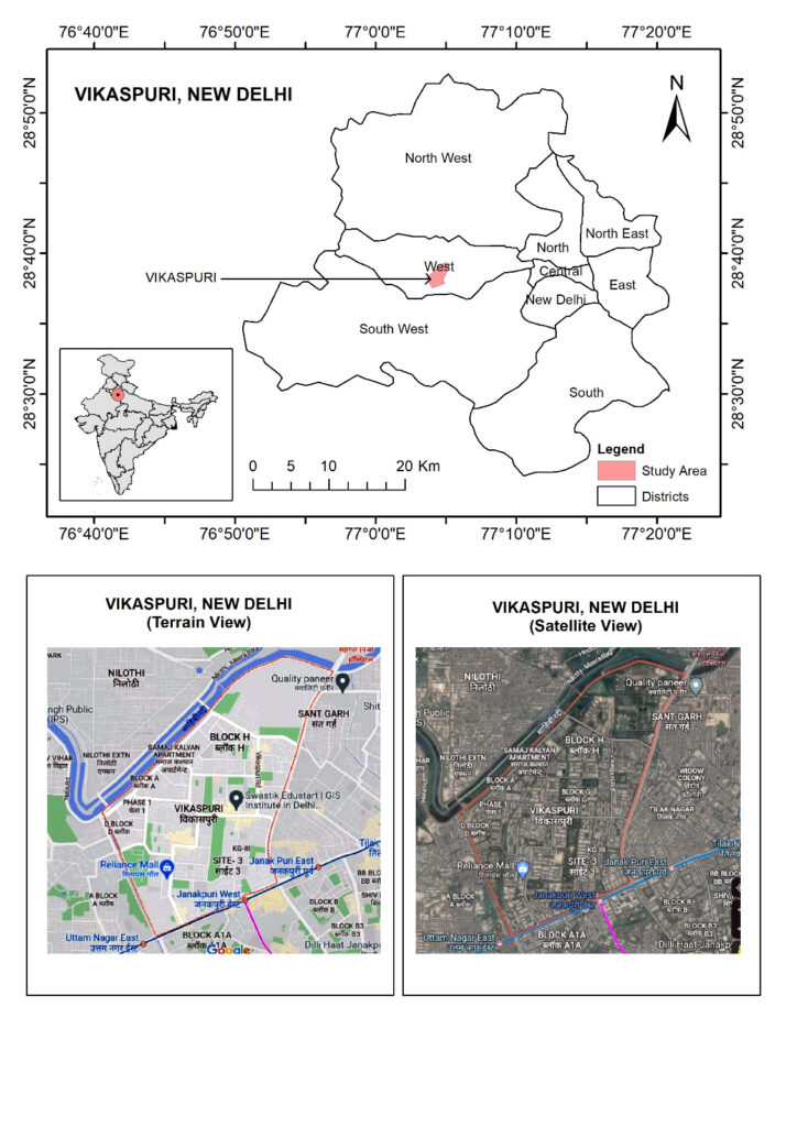
>> Location map of Vikaspuri (Delhi)
Vikas Puri Vikas Puri is a Village in West Delhi Tehsil in West Delhi District of Delhi State, India. It is located 2 KM towards East from District head quarters Rajouri Garden
It 15 KM from State capital Delhi Vikas Puri Pin code is 110018 and postal head office is Vikas Puri .
Vikas Puri is surrounded by South West Delhi Tehsil towards South , Central Delhi Tehsil towards East , North West Delhi Tehsil towards North , Bahadurgarh Tehsil towards west
Delhi , Bahadurgarh , Loni , Gurgaon are the nearby Cities to Vikas Puri
Vikaspuri locality is the most Civic and sought-after Locality located in the West Delhi area. It is a famous mid-segment locality of the West Delhi region with a strategic location. The area has been in demand for residential and commercial interest because of its proximity with the Rajouri market and expanding Metro services. Indira Gandhi International Airport and New Delhi railway station are located 20 km away from the Vikaspuri locality.
Contact us (+91 7303207023) or mail us at swastikedustart@gmail.com for more information on how to create effective location maps.
Disclaimer: The article aims to provide a basic understanding of location maps and their significance. For detailed technical guidance, consulting experts is recommended.