Skip to content
SWASTIK EDUSTART
SWASTIK EDUSTART
  • HOME
  • COURSES
    • PG Diploma-Geoinformatics
    • Diploma in GIS and Remote Sensing
    • GIS Certificate Course
    • Hydrological Modelling Certificate Course
    • Python in Data Analysis Certificate Course
    • Google Earth Engine Course
    • ACADEMICS
  • GALLARY
  • PLACEMENTS
  • BLOG
  • APPLY NOW
  • CONTACT
Enquiry Now
Enquiry Now
SWASTIK EDUSTART
SWASTIK EDUSTART
Enquiry Now
Enquiry Now
  • HOME
  • COURSES
    • PG Diploma-Geoinformatics
    • Diploma in GIS and Remote Sensing
    • GIS Certificate Course
    • Hydrological Modelling Certificate Course
    • Python in Data Analysis Certificate Course
    • Google Earth Engine Course
    • ACADEMICS
  • GALLARY
  • PLACEMENTS
  • BLOG
  • APPLY NOW
  • CONTACT
Swastikedustart logo
  • HOME
  • COURSES
    • PG Diploma-Geoinformatics
    • Diploma in GIS and Remote Sensing
    • GIS Certificate Course
    • Hydrological Modelling Certificate Course
    • Python in Data Analysis Certificate Course
    • Google Earth Engine Course
    • ACADEMICS
  • GALLARY
  • PLACEMENTS
  • BLOG
  • APPLY NOW
  • CONTACT
Enquiry Now
Enquiry Now
Swastikedustart logo
Enquiry Now
Enquiry Now
  • HOME
  • COURSES
    • PG Diploma-Geoinformatics
    • Diploma in GIS and Remote Sensing
    • GIS Certificate Course
    • Hydrological Modelling Certificate Course
    • Python in Data Analysis Certificate Course
    • Google Earth Engine Course
    • ACADEMICS
  • GALLARY
  • PLACEMENTS
  • BLOG
  • APPLY NOW
  • CONTACT

Home » Blog » Page 10

Blog

Your blog category

What is GIS?

What is GIS? Read More »

Admission Open 2024-25

Admission Open 2024-25 Read More »

Flood Risk Assessment

Webinar on Flood Risk Assessment using QGIS

Webinar on Flood Risk Assessment using QGIS Read More »

GIS Webinar

GIS Webinar Read More »

GIS_Webinar

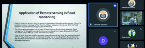
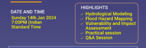
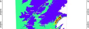
GIS Webinar on Flood Risk Assessment in QGIS – Live streaming

GIS Webinar on Flood Risk Assessment in QGIS – Live streaming Read More »

DEM MAP

Mapping : Digital Elevation Model

Mapping : Digital Elevation Model Read More »

← Previous 1 … 9 10 11 … 13 Next →

Swastik Edustart

GIS and Remote Sensing Training Insitute, provides job oriented diploma and PG diploma courses

Swastik Edustart Logo

Swastik Edustart

GIS Training Institute, Delhi

Recent Posts

  • AI in Geography: Swastik Edustart & SBSC Workshop Highlights
  • Field Tour- Bikaner (Solar Sites Visit)
  • SLOPE MAP AND ASPECT MAP OF NERMAND, HIMACHAL PRADESH
  • Amenity Map of Delhi: A Complete Guide to Understanding the City’s Educational & Urban Infrastructure
  • When the Mountains Turn Fierce: Understanding Flood Inundated Areas in Chamba, Uttarakhand
Know More
ABOUT

Swastik Edustart GIS Training Institute ensures that our students feel fulfilled by integrating practical skills and staying updated with current industry trends. We are reputed and the best GIS training institute in Delhi/NCR & across India. Certified training by ITT Council.

Powered by SWASTIK EDUSTART

GIS Training Courses

GIS Certificate Training | Diploma in GIS and Remote Sensing | PG Diploma in Geoinformatics