Introduction
Amenity mapping is a crucial aspect of urban planning, especially in a bustling metropolis like Delhi. With a population exceeding 20 million, the efficient distribution and accessibility of amenities such as parks, hospitals, schools, and transportation facilities are vital for enhancing the quality of life for residents. This article delves into the concept of amenity mapping in Delhi, its significance, methodologies, and the future it holds for urban development.
What is Amenity Mapping?
Amenity mapping is the process of identifying, analyzing, and visualizing public amenities within a geographical area. It provides a detailed overview of available facilities and their distribution, helping urban planners and policymakers make informed decisions. In Delhi, this mapping plays a pivotal role in addressing challenges like overcrowding, resource allocation, and sustainable development.
Why is Amenity Mapping Important in Delhi?
- Enhanced Quality of Life: By identifying gaps in amenity distribution, planners can work to ensure equitable access to essential services.
- Data-Driven Decision Making: Amenity mapping provides crucial data for government bodies and NGOs, allowing them to prioritize developments based on community needs.
- Sustainable Urban Growth: Understanding amenity distribution helps in planning for sustainable growth and minimizing environmental impacts.
- Community Engagement: Involving residents in the mapping process fosters a sense of ownership and can lead to more effective urban planning.
Key Amenities in Delhi
- Healthcare Facilities: Access to hospitals and clinics is crucial for public health. Mapping these facilities helps identify underserved areas.
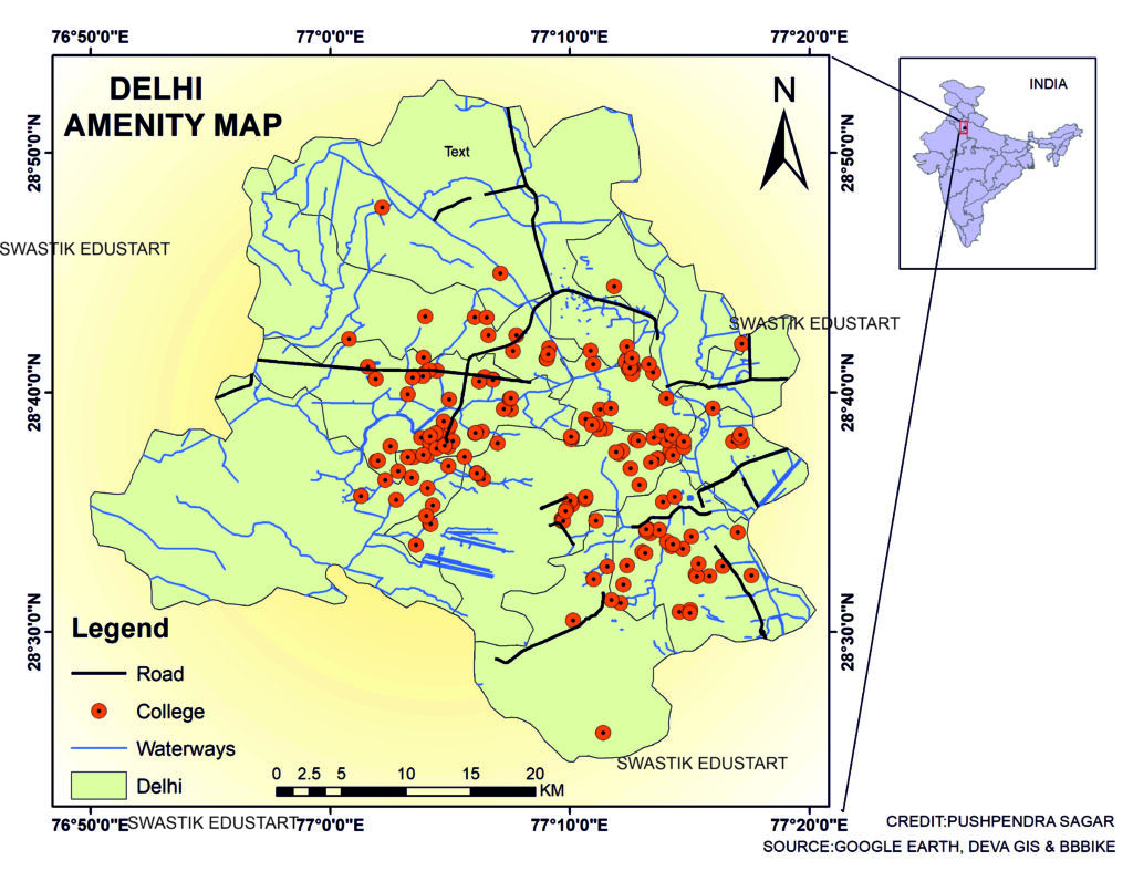
- Educational Institutions: Schools and colleges are fundamental for community development. Amenity mapping can highlight areas lacking educational resources.
- Recreational Spaces: Parks and sports complexes are essential for mental and physical well-being. Understanding their distribution aids in promoting healthier lifestyles.
- Transportation Networks: Efficient public transport is key for a city like Delhi. Mapping bus routes, metro stations, and connectivity helps enhance mobility.
Methodologies for Amenity Mapping
- Geographic Information Systems (GIS): GIS technology is widely used for creating detailed maps that visualize amenity locations, types, and accessibility.
- Surveys and Community Feedback: Engaging with residents through surveys can provide qualitative data that enhances mapping accuracy.
- Satellite Imagery: Utilizing satellite imagery allows for the assessment of land use and identification of new developments.
- Mobile Applications: New technologies, such as mobile apps, enable real-time data collection and user interaction in mapping efforts.
Case Studies: Successful Amenity Mapping in Delhi
- Delhi Development Authority (DDA): The DDA has initiated several projects that utilize amenity mapping to improve urban infrastructure and public services. Their website offers insights into ongoing and completed projects. DDA Official Site
- Smart City Mission: Under this initiative, various local bodies are using amenity mapping to enhance urban services. This approach is critical in areas like Dwarka and Rohini, where rapid urbanization demands effective planning.
- Non-Governmental Organizations: NGOs like The Urban Project have been instrumental in conducting participatory mapping exercises, bringing community voices into the planning process. The Urban Project
Challenges in Amenity Mapping
Despite its advantages, amenity mapping in Delhi faces several challenges:
- Data Availability: Accurate and up-to-date data can be hard to obtain due to bureaucracy and lack of comprehensive databases.
- Funding and Resources: Many urban planning projects struggle with limited budgets, affecting the implementation of mapping initiatives.
- Stakeholder Engagement: Engaging various stakeholders, including government bodies, residents, and businesses, can be complex and time-consuming.
The Future of Amenity Mapping in Delhi
As technology evolves, the future of amenity mapping in Delhi looks promising. Innovations such as artificial intelligence and big data analytics are set to enhance data collection and analysis processes. Furthermore, integrating community feedback into mapping efforts will ensure that urban planning aligns more closely with the needs of residents.
Conclusion
Amenity mapping in Delhi is more than just a planning tool; it’s a vital component of sustainable urban development. By understanding and addressing the distribution of essential services, we can enhance the quality of life for millions of residents. As we move forward, embracing technology and community engagement will be key to successful urban planning in this dynamic city.
Internal Links
External Links
By effectively leveraging amenity mapping, Delhi can pave the way for a more inclusive and sustainable urban future.
AmenityMappingDelhi #UrbanPlanning #DelhiDevelopment #SustainableCities #SmartCity