
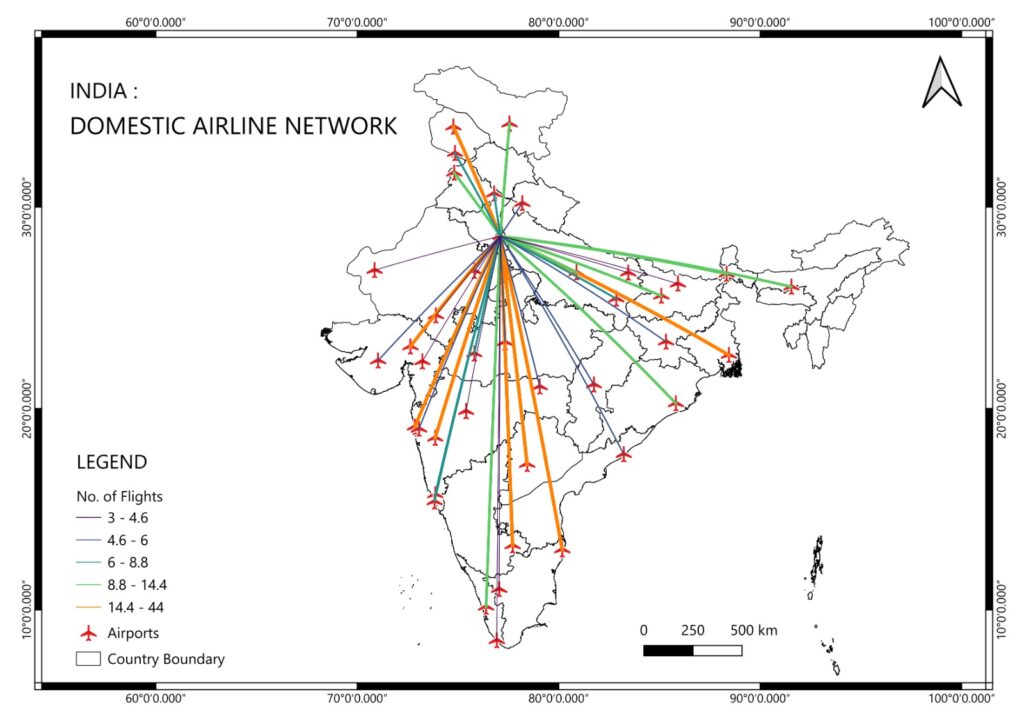
India: Domestic Airline Network GIS Mapping Work
India has one of the fastest-growing aviation sectors in the world, with hundreds of domestic flights connecting metropolitan cities, regional airports, and remote locations every day. India: Domestic Airline Network GIS Mapping Work plays a significant role in understanding airport connectivity, flight route planning, accessibility, passenger demand, and transportation infrastructure.
With the rapid growth of GIS, Remote Sensing, AI, Big Data, and Digital Twin technologies in 2026, aviation organizations increasingly rely on Geographic Information Systems (GIS) for network analysis, airport planning, logistics optimization, and decision-making.
Whether you are a GIS beginner, researcher, or aspiring geospatial professional, learning airline network mapping can open exciting career opportunities.
Why GIS is Important for India’s Domestic Airline Network
GIS allows aviation planners and transportation authorities to visualize, analyze, and optimize airline routes using spatial data.
Major applications include:
- Mapping domestic airline routes across India
- Airport accessibility analysis
- Flight connectivity visualization
- Passenger demand analysis
- Regional connectivity planning
- Emergency response and disaster management
- Airport catchment area analysis
- Air traffic infrastructure planning
- Aviation logistics and cargo network optimization
GIS converts complex airline data into interactive maps that help planners make faster and smarter decisions.
Components of Domestic Airline GIS Mapping
A complete airline network GIS project generally includes:
1. Airport Location Mapping
Every airport is represented using latitude and longitude coordinates.
Examples include:
- Indira Gandhi International Airport (Delhi)
- Chhatrapati Shivaji Maharaj International Airport (Mumbai)
- Kempegowda International Airport (Bengaluru)
- Chennai International Airport
- Netaji Subhas Chandra Bose International Airport (Kolkata)
2. Airline Route Network
Flight routes are mapped as line features connecting airports.
GIS can identify:
- Direct routes
- Hub-and-spoke networks
- Regional connectivity
- High-density flight corridors
3. Spatial Network Analysis
Using GIS Network Analysis tools, planners can evaluate:
- Shortest air routes
- Airport service areas
- Route redundancy
- Accessibility
- Connectivity between Tier-2 and Tier-3 cities
4. Passenger Flow Mapping
GIS dashboards can visualize:
- Passenger volume
- Seasonal travel demand
- Peak travel corridors
- Tourism-related aviation growth
Data Sources for Airline GIS Mapping
Reliable GIS analysis depends on quality spatial data. Beginners can start with freely available datasets and open-source GIS software.
Useful resources include:
- QGIS (Open Source GIS Software): https://qgis.org
- Natural Earth Data: https://www.naturalearthdata.com
- OpenStreetMap: https://www.openstreetmap.org
- NASA Earthdata: https://earthdata.nasa.gov
These platforms provide free datasets that can be integrated into GIS projects for airport locations, administrative boundaries, transportation layers, and environmental analysis.
GIS Techniques Used in Airline Network Analysis
Modern aviation GIS projects involve several advanced techniques:
Airport Buffer Analysis
Study airport influence zones.
OD (Origin-Destination) Analysis
Understand passenger movement between cities.
Spatial Statistics
Analyze passenger density and airport distribution.
Heat Maps
Visualize busy aviation corridors.
Service Area Analysis
Identify regions with poor airport accessibility.
Web GIS Dashboards
Publish interactive airline maps for public use.
GeoAI Integration
Predict future airline demand using Artificial Intelligence.
2026 Trends in Aviation GIS
The aviation sector is rapidly adopting advanced geospatial technologies, including:
- AI-powered route optimization
- Real-time flight GIS dashboards
- Digital Twin airports
- Drone integration
- 3D airport visualization
- Big Data spatial analytics
- Cloud GIS platforms
- Predictive aviation planning
- Smart airport management systems
- IoT-enabled airport infrastructure monitoring
These technologies are transforming how airline networks are planned and managed across India.
Learn Airline GIS Mapping with Swastik Edustart
If you want practical experience in aviation GIS projects, Swastik Edustart – GIS Training Institute, Delhi provides industry-oriented training with real-world mapping assignments.
Students work on transportation, aviation, urban planning, environmental management, disaster management, and geospatial analytics projects using professional GIS software.
Popular courses include:
- Diploma in GIS and Remote Sensing
- PG Diploma in Geoinformatics
- Customized GIS and Remote Sensing Certificate
- GIS Certificate Course
The training emphasizes hands-on learning with QGIS, ArcGIS, Google Earth Engine, Python for GIS, Remote Sensing, Spatial Analysis, Cartography, and GeoAI, helping students build job-ready skills for the geospatial industry.
Learn more at https://swastikedustart.com/.
Career Opportunities After Learning Airline GIS Mapping
Professionals with aviation GIS skills are increasingly in demand across government organizations, airports, airlines, logistics companies, infrastructure consultancies, and geospatial firms.
Popular job roles include:
- GIS Analyst
- Transportation GIS Specialist
- Aviation Planner
- Spatial Data Analyst
- Remote Sensing Analyst
- GIS Consultant
- Airport Infrastructure Planner
- Network Planning Analyst
- Geospatial Data Scientist
- GIS Project Engineer
As India’s aviation network expands under regional connectivity initiatives and smart infrastructure development, skilled GIS professionals will continue to be highly sought after.
Conclusion
India: Domestic Airline Network GIS Mapping Work demonstrates how spatial technology supports smarter aviation planning, improved connectivity, efficient airport management, and informed infrastructure development. With the growing adoption of AI, GeoAI, Digital Twins, and cloud-based GIS in 2026, aviation mapping has become an exciting and future-ready career domain.
If you aspire to build expertise in GIS and Remote Sensing, Swastik Edustart – GIS Training Institute, Delhi offers comprehensive, practical training through its Diploma in GIS and Remote Sensing, PG Diploma in Geoinformatics, Customized GIS and Remote Sensing Certificate, and GIS Certificate Course. These programs are designed to equip students with the technical skills needed for careers in aviation, transportation, urban planning, environmental management, and geospatial data science.
Primary & Secondary SEO Keywords
Primary Keyword:
- India: Domestic Airline Network GIS Mapping Work
Secondary Keywords:
- India airline GIS mapping
- Domestic airline route mapping India
- Aviation GIS
- Airport GIS analysis
- Airline network analysis GIS
- Transportation GIS India
- GIS for aviation planning
- Airport accessibility mapping
- Flight route GIS
- GIS training institute Delhi
- Diploma in GIS and Remote Sensing
- PG Diploma in Geoinformatics
- GIS Certificate Course
- GeoAI in aviation
- Digital Twin airports
- Remote Sensing applications
- Aviation spatial analysis
- GIS career opportunities 2026
Hashtags
#GIS #RemoteSensing #Geoinformatics #AirlineNetwork #AviationGIS #TransportationGIS #IndiaGIS #SpatialAnalysis #QGIS #ArcGIS #GeoAI #DigitalTwin #SmartAirports #GISCareer #GISTraining #SwastikEdustart #Delhi #Geospatial #OpenData #NetworkAnalysis