Introduction
Land Use and Land Cover (LULC) change detection is a crucial tool for understanding how cities evolve over time. In Varanasi, one of India’s oldest and most dynamic cities, rapid urbanization has significantly transformed its landscape. Using remote sensing data from USGS Explorer, this study visualizes the shift in land use patterns between 2015 and 2025.
Key Highlights from the LULC Maps
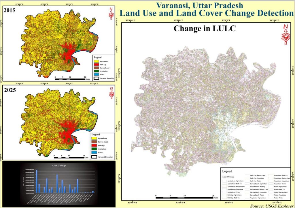
The LULC maps (2015 and 2025) reveal notable spatial changes in five main categories:
- Agriculture
- Built-Up Area
- Barren Land
- Vegetation
- Water Bodies
1. Growth of Built-Up Areas
From 2015 to 2025, built-up areas (marked in red) have expanded dramatically. This is a clear indicator of urban growth, infrastructure development, and population influx into Varanasi’s core and peripheral regions.
2. Decline in Agricultural Land
Agricultural areas (yellow) have shrunk considerably, especially around the city’s periphery. This trend suggests that farmlands are being converted into residential, commercial, and industrial zones.
3. Vegetation and Barren Land Changes
Green patches representing vegetation have reduced, while barren land shows mixed trends—some areas have been converted to agriculture, while others are transitioning into built-up zones.
4. Water Body Stability
Water bodies (blue) show relative stability but may experience quality and quantity stress due to increased urban runoff.
Change in LULC – A Visual Overview
The Change in LULC map visually depicts the specific land category transitions, such as “Agriculture to Built-Up” or “Vegetation to Barren Land.” This granular analysis helps policymakers and urban planners target sustainable development initiatives.
Area Change Graph
The area change chart at the bottom of the figure highlights the quantitative shifts in each land category. The spikes in built-up land and declines in agriculture are especially evident here.
Why LULC Change Detection Matters for Varanasi
- Urban Planning: Helps the city government plan roads, drainage, and housing.
- Environmental Protection: Identifies shrinking green spaces to prioritize afforestation.
- Water Resource Management: Monitors the health of rivers and ponds amid urbanization.
- Disaster Preparedness: Assists in flood risk assessment and climate adaptation measures.
SEO-Friendly Keywords
- Land Use and Land Cover Change in Varanasi
- LULC Mapping Uttar Pradesh
- Urbanization Trends in Varanasi
- Remote Sensing for Land Use Change
- Built-Up Area Growth Varanasi
- Agriculture to Urban Land Conversion
Conclusion
The LULC change detection between 2015 and 2025 reveals a clear pattern of urban expansion in Varanasi at the expense of agriculture and vegetation. By leveraging GIS and remote sensing, stakeholders can plan better for sustainable growth, balancing development with environmental preservation.

