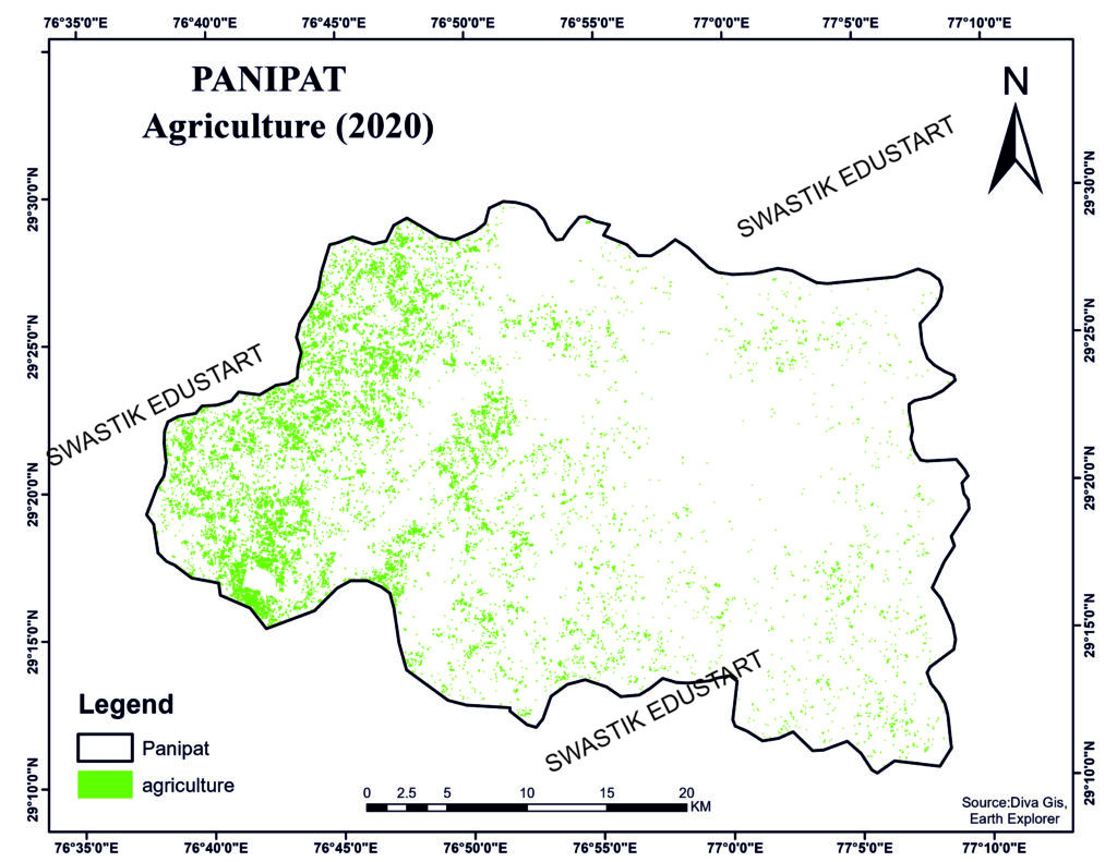
Agriculture plays a vital role in Panipat, Haryana, where farming is a primary occupation. However, the rapidly changing climate and growing need for efficient land use have made traditional farming methods less viable. Agriculture mapping has emerged as a powerful tool for farmers in the region, helping them increase productivity, ensure sustainable practices, and make informed decisions using Geographic Information System (GIS) and remote sensing technologies.
In this blog, we’ll dive deep into how agriculture mapping is transforming the farming landscape in Panipat, the technologies involved, and its impact on sustainability and productivity.
What is Agriculture Mapping?
Agriculture mapping refers to the use of GIS, remote sensing, and related technologies to monitor, map, and analyze agricultural land. The goal is to provide actionable insights that help farmers manage their crops, optimize water resources, and improve overall agricultural productivity. These maps are generated using satellite images, drones, and on-ground data, providing detailed information about crop health, soil conditions, irrigation needs, and more.
In Panipat, agriculture mapping is increasingly being adopted as a solution to improve crop yields, conserve resources, and practice precision farming. The district is known for producing crops like wheat, rice, and sugarcane, and using modern technology can help ensure these crops are grown sustainably.
Key Benefits of Agriculture Mapping in Panipat
1. Improved Crop Health Monitoring
One of the key benefits of agriculture mapping is real-time crop health monitoring. By using satellite images and drones, farmers can get detailed visualizations of their fields. NDVI (Normalized Difference Vegetation Index) analysis can identify which parts of a field need attention, whether due to nutrient deficiencies, pest infestations, or water stress.
In Panipat, where crops like wheat and rice dominate, timely information on crop health can save farmers from huge losses due to undetected problems.
2. Optimized Water Use
Water scarcity is a major concern in Haryana, and Panipat is no exception. Agriculture mapping allows for the precise allocation of water resources, ensuring that crops receive just the right amount of water. By analyzing soil moisture and irrigation needs, water consumption can be reduced, resulting in more efficient farming and conservation of vital resources.
3. Precision Farming
Precision farming involves using technology to ensure that crops get what they need in terms of nutrients, water, and protection from pests and diseases. GIS-based agriculture mapping is a key component of precision farming, allowing farmers to apply fertilizers and pesticides only where needed, reducing both costs and environmental impacts.
4. Soil Health Management
Soil mapping is an integral part of agriculture mapping. By analyzing soil samples and combining them with satellite data, farmers in Panipat can better understand soil health across their fields. Different zones in a field may require different treatment based on soil type, pH levels, and organic content. This helps in implementing targeted soil improvement strategies, leading to higher productivity.
How GIS and Remote Sensing are Used in Panipat Agriculture Mapping
1. Satellite Imagery
Satellites provide high-resolution images that cover large agricultural areas. These images can be processed to generate various indices like NDVI, which highlights crop health based on photosynthetic activity. The frequent revisit time of satellites like Sentinel-2 or Landsat makes it possible to monitor crops at critical growth stages.
2. Drones
In recent years, drone technology has made its way into agriculture mapping. Drones offer a more localized and high-resolution view of agricultural fields. In Panipat, drones are being used to map crop health, assess damage after natural disasters, and generate real-time data for decision-making.
3. Geographic Information Systems (GIS)
GIS serves as the platform for integrating satellite, drone, and field data. In Panipat, GIS tools help in creating comprehensive maps that not only depict crop health but also show irrigation patterns, soil types, and land use. With these maps, farmers can visualize their fields in ways they never could before, enabling them to make informed decisions.
The Impact of Agriculture Mapping on Sustainability
1. Reduced Environmental Impact
By enabling precision farming, agriculture mapping helps reduce the amount of fertilizers, pesticides, and water used, thereby reducing the overall environmental impact of farming practices. The focus on optimizing inputs based on real-time data leads to more sustainable farming practices, which is critical in regions like Panipat that are dealing with climate change and resource scarcity.
2. Conservation of Water Resources
Haryana is a water-scarce state, and the use of agriculture mapping helps in the efficient use of this precious resource. Irrigation systems can be better managed to ensure that water is delivered only where it is needed. This can be especially beneficial for crops like rice that require a large amount of water.
3. Long-Term Productivity
Sustainable farming practices driven by data from agriculture mapping ensure that the soil remains healthy, water resources are conserved, and inputs are optimized. This ensures that farmland in Panipat remains productive for future generations.
Challenges in Implementing Agriculture Mapping in Panipat
Despite the benefits, there are challenges to implementing agriculture mapping on a large scale in Panipat. These include:
- High Initial Costs: Setting up the technology for agriculture mapping, such as drones and GIS software, can be expensive for small-scale farmers.
- Lack of Awareness: Many farmers are still unaware of the benefits of GIS and remote sensing technologies.
- Data Accessibility: Getting real-time and affordable access to high-resolution satellite imagery or drone services can be difficult in rural areas.
Conclusion
Agriculture mapping is transforming the way farming is done in Panipat, offering farmers the tools to optimize their resources, increase yields, and ensure long-term sustainability. By adopting GIS, satellite imagery, and precision farming techniques, the region is poised to overcome the challenges posed by resource constraints and climate change.
As agriculture mapping technology becomes more affordable and accessible, it holds the potential to revolutionize not only Panipat’s agriculture but farming across India.
External Backlinks:
- Learn more about GIS in agriculture
- How precision farming is changing agriculture
- Water resource management in Haryana
- NDVI and its role in crop monitoring
AgricultureMapping #PanipatAgriculture #SustainableFarming #GISInAgriculture #CropMonitoring #PrecisionFarming #AgriTech #HaryanaFarming #GeospatialAnalysis


